


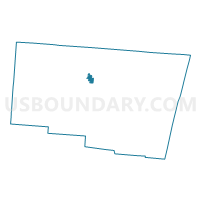
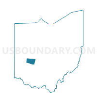
Voting District CITY 31, Clark County, Ohio
About
Outline

Summary
| Unique Area Identifier | 643434 |
| Name | Voting District CITY 31 |
| County | Clark County |
| State | Ohio |
| Area (square miles) | 0.70 |
| Land Area (square miles) | 0.70 |
| Water Area (square miles) | 0.00 |
| % of Land Area | 100.00 |
| % of Water Area | 0.00 |
| Latitude of the Internal Point | 39.95520430 |
| Longtitude of the Internal Point | -83.81202380 |
Maps

Graphs
Select a template below for downloading or customizing gragh for Voting District CITY 31, Clark County, Ohio


Neighbors
Neighoring Voting District (by Name) Neighboring Voting District on the Map
- Voting District CITY 26, Clark County, OH
- Voting District CITY 27, Clark County, OH
- Voting District CITY 28, Clark County, OH
- Voting District CITY 30, Clark County, OH
- Voting District CITY 32, Clark County, OH
- Voting District MFLD 1, Clark County, OH
- Voting District T-2, Clark County, OH
Top 10 Neighboring County Subdivision (by Population) Neighboring County Subdivision on the Map
- Springfield city, Clark County, OH (60,608)
- Moorefield township, Clark County, OH (12,436)
- Springfield township, Clark County, OH (12,237)